Map: Detroit Protests 2020

DETROITography

Detroit-Protests-2020-061220AH

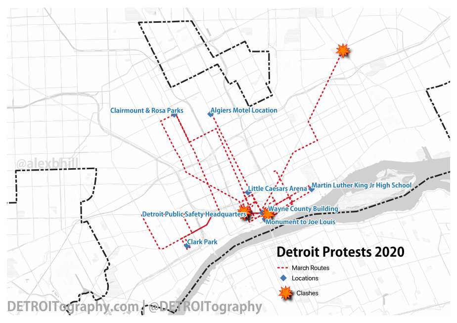
Over the last 14 days, protestors in Detroit have marched a collective 74 miles through Corktown, Southwest, Downtown, Midtown, Virginia Park, New Center, Islandview, and deep into the Eastside.

Protestors are demanding justice for George Floyd and the numerous other Black Americans who have died or faced brutality at the hands of police. The structural violence of expanded video surveillance, rampant foreclosures, unfettered evictions, and broad disinvestment in Black neighborhoods has also been a focal point of protestors demands delivered to the Mayor.

In the early days, marches were met with an intense and often brutal police response with full riot gear and tear gas. Clashes have been driven by police responding to the defined curfew which led to mass arrests until the Police Chief declared he would no longer enforce the curfew. Marches following this declaration saw no clashes and always ended peacefully. Marches have pulled…

View original post 73 more words

Map: Detroit’s Altered Grocery Landscape 2020

DETROITography

DFM-covid-grocery-050820Food isn’t the same in Detroit anymore. All independent grocers have reduced their operating hours – many have reduced staff as workers stopped showing up for fear of exposure. Restaurants are becoming small grocers, “groceries” are distributed in drive-thru lines, and emergency food providers have become a lifeline as unemployment has skyrocketed.

Retailers are now mandated to limit the number of people inside their stores, require all employees (and customers) wear masks, and offer special hours to vulnerable populations.

As part of the Detroit Grocery Coalition, convened by the Detroit Food Policy Council, I’ve been tracking changes along with colleagues at the City of Detroit. Independent grocers are holding steady in the neighborhoods although at reduced staffING, hours, and sometimes supply chain – but the landscape of support during COVID-19 shows specific food access opportunity patterns across Detroit.

View original post

Map: Arsenal of Health in Detroit 2020

DETROITography

arsenal-of-health

During both World War efforts, Detroit’s factories and their manufacturing might was flipped from automobile production to support for the war effort. During World War II, at least 110 factories in Detroit retooled to produce parts for aircraft, tanks, and weapons.

arsenal-of-democracy

Recently, the news media (Crains, Free Press, Detroit News) have reached back into history in an attempt to compare the Coronavirus global pandemic to a war effort. There are serious issues with comparing a public health response to a war, but today is all about the geography.

Detroit no longer has an arsenal from which to pull. There are no longer over 100 factories within the city limits. The auto industry’s operations are no longer are located in Detroit. The reverse prohibition trend in Detroit has led to the city’s strongest response as Detroit-based breweries and distilleries have started mass producing hand sanitizer rather than beer or spirits. Detroit’s…

View original post 130 more words

Map: Coffee Shop Shifts in Detroit 2017 – 2019

DETROITography

coffeedensity2019-v2.png

In 2015 I wanted to see how coffee shops in Detroit might relate to research on Starbucks and gentrification. I tracked on-going changes in the coffee landscape in 2017. Now there are more changes in coffee, but it’s more a consolidation than citywide growth. There are a few upcoming neighborhood coffee venues planned, such as Morningside Cafe.

Neighborhoods adjacent to the 7.2 square mile Downtown-Midtown investment zone are seeing expansion and new coffee shops opening up adding to existing density of coffee options. However, neighborhoods a bit further out are starting to lose their coffee shops where there was no change between 2015 to 2017. Most notably Ashe Coffee’s attempt in Rivertown was a flop and the rarely open Coffee and (_____) closed its doors in Jefferson Chalmers. Will Leather Goods (former Tomboy Market) hosted a coffee bar, but everything is closing down to make way for another pizza…

View original post 109 more words

Map: The Shifting Cost of Coworking in Detroit 2014 to 2017

DETROITography

cowork_landscape_2017

Since 2014, I’ve been following the coworking trend in Detroit. I’ve used space for team work at An Office in Detroit that has seen a change in ownership, but is still going strong. In the last 3 year, there have been 8 coworking spaces that have closed and 13 new spaces opened, including the arrival of WeWork in two Downtown locations and the expansion of Bamboo Detroit into a second space. It is safe to say that the majority of the action is located Downtown within the 48226 zip code.

coworking-2017costchange

The most interesting coworking shift has been change in the monthly price of a drop-in desk or “hot desk.” Out of the 13 spaces that have been operating since 2014, 6 increased their prices, 2 dropped prices, and 5 kept prices the same (first map). In 2014 the average cost of a coworking desk was around $110, but in 2017…

View original post 101 more words

Map: Basketball Hoops per capita for Children in Detroit 2017

DETROITography

hoops-per-child

Basketball is the most popular sport by far in Southeast Michigan according to the “State of Play” report by the Ralph C. Wilson Jr. Foundation. A friend asked me last month if there was any data on all the basketball courts in the city. I knew that the parks kept track of amenities, but that wouldn’t capture all the available courts and hoops in the city that might be located at schools, churches, etc.

I embarked on the joyous adventure of combing Detroit from the skies via Google’s Satellite Imagery and a grid of the city. Basketball courts, it turns out, are fairly easy to spot because of the size of paved space needed, the signature painted lines, and the shadow of basketball poles. Surprisingly, many schools do not have outdoor basketball amenities and many churches have partial courts in their parking lots.

This was in no way…

View original post 75 more words

Map: Coney Detroit 2017

DETROITography

Coney-Detroit-2017-map

The coney dog was born in Detroit. The 2012 book titled Coney Detroit attributes the “coney dog” to Greek emigrants who likely passed through Ellis Island in New York (near the birthplace of the hot dog, Coney Island).

Coney dogs were cheap and quick allowing them to propagate outside of Detroit’s major factories. Workers had short lunches and limited budgets – the coney dog was the answer.

Today, there are multiple opportunities to eat at a Coney Island restaurant or diner. There are a few coney chains in the Southeast Michigan region and in the City of Detroit there are some coney clusters. Detroit’s Downtown is home to the Lafayette versus American rivalry, Northwest has Coney Islands right next to each other and includes Nicky D’s, while East of the State Fairgrounds sports a string of coneys mostly along Conant Street.

View original post

Map: Languages Spoken in Detroit Homes 2014

DETROITography

language-home-map

Households in Detroit in general are homogeneous; the city ranks low on the diversity scale due to the 83% majority African-American population. However, the city has incredibly concentrated neighborhoods of cultural significance. Detroit remains a global city.

Southwest Detroit is most often referred to as Mexicantown due to the large Mexican-American population that can be traced back for decades in the city. There was a small, but growing Mexican foreign born population in the 1960s (map). The increase in Mexican immigration was due in large part to the industrial jobs offered by Henry Ford. Mexican-Americans are currently the largest single immigrant group in Wayne, Oakland, and Macomb counties.

Warrendale, on the city’s lower Westside, neighbors Dearborn and has a similar history of Middle Eastern immigrants with the first coming in the 1870s. Various waves of immigration followed Middle Eastern conflict such as the Lebanese Civil War, the Gulf…

View original post 105 more words

Map: Detroit is Full of Old Housing

DETROITography

pre-1978-residential-2

Housing in Detroit is often discussed in terms of its absence or dilapidation. It’s no wonder that Detroit’s housing stock has suffered over the decades of job loss, disinvestment, and discrimination. When nearly 40% of residents live below the poverty line, investing in housing comes secondary to food, water, heat, etc. The vast majority of the city (93%) was built before 1978 when the Lead Rule banning lead in paint was adopted.

The city saw a housing boom during and after World War II when thousands of people migrated to Detroit for good paying jobs which at the time made up one-sixth of all employment in the country. Currently, 62% of residential housing was built before 1950 in Detroit.

Internationally, housing has been shown to be a critical component of good health. Whether it is providing a cement floor and tin roof to families in Haiti or ensuring routine maintenance…

View original post 40 more words