Blog

State of Detroit – Detroit’s Food Landscape

Alex B. Hill's avatarDETROITography

IMG_7920
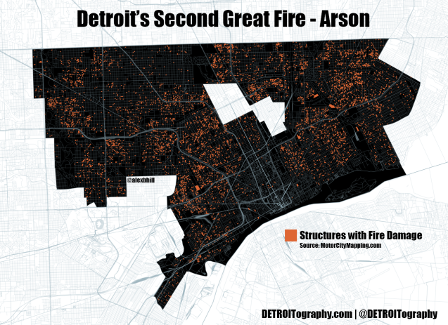
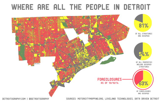
The team at the Chicago Design Museum approached me to contribute some maps and data visualizations to their upcoming “State of Detroit” exhibit. It grew into a collaboration that built off of my research focus on food access in Detroit while also addressing some of the “Detroit is Empty” misconceptions.

IMG_7919
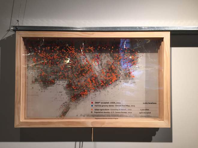
The installation has a cool sliding feature so you can view different map layers together.

Visit the exhibit from now until August 30th, 2015. More. . .

View original post

Beijing and the Great Wall Adventure

Alex B. Hill's avatarEight Twelve Eleven

China!

The mass of people that represents China was no more evident than when we arrived at the gates to the Forbidden City. We encountered many Chinese tourists while in Taiwan, but nothing prepared us for the masses that visit China’s capital city, including the short elderly women who attempt to clothesline you (ask Nichole). The pushing and pressing of the crowds were sometimes too much, giving a whole new meaning to breath-taking.

DSCF6686

Ancient History!

I can’t even tell you how many ancient and amazing temples we visited in both Taiwan and China. Most of our time in China was spent walking between various ancient structures: Forbidden City (13 miles walked), Temple of Heaven (15.5 miles walked), Summer Palace, Drum and Bell Tower, etc.

IMG_3824DSCF6776IMG_3727Nichole conferred with Confucius. She is now overflowing with wisdom.

DSCF6904

Communism!

From the cold, gray heart of communism we snapped a great selfie with Mao’s portrait…

View original post 648 more words

Map: Can Detroit Really Be Compared to Any Other City?

Alex B. Hill's avatarDETROITography

detroit-cities3

Can Detroit really be compared to any other city? No doubt everyone has tried comparing crime rates, economy, and poverty levels in Detroit with other troubled cities. A few groups have even tried fitting different city land areas into Detroit’s 139 square (land) miles. It always seems that Detroit has too much or too little of something for a city to city comparison to make much sense. Rob Linn had similar thoughts and instead of comparing land area or other commonly compared attributes he analyzed infrastructure density (feet of street per resident) as a method to debate the misguided “rightsizing” push. Rob found that Detroit had a high rate of “feet of street per resident” which caused some areas of the city to appear more vacant when in reality they had healthier infrastructure density.

The 2010 Census population for Detroit was 713,777, closer to San Francisco’s. Imagine San Francisco’s southern edge…

View original post 391 more words

Taiwan Teddy Tourism

Alex B. Hill's avatarEight Twelve Eleven

Obviously Nichole and I love international travel. This is our latest international adventure.

Nichole had been very young the first time she visited Taiwan and I had never traveled anywhere in Asia, so we planned a trip, packed our bags, and prepared for a new experience. My wife’s uncle, Todd, studied Chinese in college and ended up completing a year abroad in Taiwan where he fell in love with his wife, Jackie. They have two awesome boys, Austin and Colin. We couldn’t have asked for better hosts and tour guides throughout our trip!

The flight to China I think is the longest that I have ever flown. We took the cost saving route and had an extra long layover (8 hours) in Houston. Nichole slept a lot (read: the entire flight) and I watched all the movies from the past year that I hadn’t seen. We finally landed in Beijing…

View original post 536 more words

Map: Detroit’s Second Great Fire

Alex B. Hill's avatarDETROITography

mcm-fire

Detroit’s “Great Fire” of 1805 is solidified in the history books as a defining moment for the city. With only the brick chimneys remaining, Detroit residents dug in and rebuilt their city. Justice Woodward drew up his inspired hub-and-spoke street plans (1806) to bring Detroit on par with cities like Paris and Washington D.C. Following the “Great Fire” Detroit saw continued progress and became one of the most well-known cities in the world for its industry.

However, Detroit has had a more recent “Great Fire,” one that began in the 1970s and is most often seen on display during Devil’s Night. As Detroit’s population declined and crime increased, both dedicated residents and criminals took to setting abandoned homes on fire. A news segment from 1975 features an interview with two Detroit residents talking about how they decided to torch an abandoned house on their block because it…

View original post 133 more words

Is Detroit’s Data More Open?

Alex B. Hill's avatarDETROITography

image (3)

Almost half the “datasets” that the City of Detroit released are simplified duplicates of larger datasets or visualizations. In truth the city released about 46 datasets, about half of the “over 90” datasets that were announced. Out of the 46 actual datasets released, only 28 are new datasets that couldn’t already be found at the old City of Detroit GIS page, Data Driven Detroit (D3), or DetroitData.org. This is still an incredible gain for open data. I just don’t understand the reason behind inflating the numbers.

After years of a substandard webpage with download links to GIS files, the City of Detroit entered the modern open data era with a Socrata data platform supported (read: free) from their new Socrata Foundation. The city has been trumpeting that it has released over 90 datasets to the public. This would be an incredible feat in a formerly bankrupt government with multiple departments spread…

View original post 734 more words

Data: 290,439 Michiganders signed up for new health coverage in 2015

Alex B. Hill's avatarMICHUHCAN

ACA_coverage_2015The U.S. Department of Health and Human Services (HHS) reports that 290,439 Michiganders signed up for health coverage that will start on February 1st.

The next enrollment period runs from February 15th – March 1st.

HHS says that about 6.5 million people have signed up or renewed their health coverage in the marketplace since November 15th.

View original post

Map: Where Are All the People in Detroit – Occupancy and Foreclosure

Alex B. Hill's avatarDETROITography

det-occupied2There is a common media narrative that Detroit is empty, a blank slate, a blank canvas where anything can be done. However, this false narrative doesn’t account for the nearly 700,000 people who do live in the city. I pulled all of the “occupied, partially occupied, and possibly occupied” properties out of the Motor City Mapping (MCM) data and the above map is the result.

I found 203,723 occupied structures, which is an 81% structure occupancy rate and a total of 54% of properties with occupied structures. This doesn’t necessarily account for parks or large unused former industrial properties. The map however gives a far different picture than the common media narrative of an empty Detroit.

det-occupied-foreclosures2This year the Wayne County Treasurer identified 61,912 properties in Detroit for foreclosure in 2015. Loveland Technologies found that 35,669 of these properties (63%) are occupied according to the MCM survey data. More from…

View original post 116 more words